A abampere (aA) The unit of electric current in the CGSeniu system, defined as that current that, if flowing through two parallel conductors of negligible cross section and infinite length, placed 1 cm apart in vacuo, would produce on each conductor a force of 1 dyne per centimeter of length. 1 abampere = 1 abcoulomb/s = r statampere (where c = speed of light in cm/s) = 10 ampere. aberration Imperfect image formation due to geometric imperfections in the optical elements of a system ablation 1 . The wasting of glacier ice by any process (calving, melting, evaporation, etc.). 2. The shedding of molten material from the outer sur- face of a meteorite or tektite during its flight through the atmosphere. absolute age The age of a natural substance, of a fossil or living organism, or of an artifact, obtained by means of an absolute dating method. See absolute dating method. absolute density Density in kg/m' or, more commonly, in g/cm\ both at STP. Cf. density, relative density abso
Lifelines of National Economy class 10 ncert geography MCQ & SAQ
Lifelines of National Economy class 10 ncert geography NCERT SOLUTION:
(i) Which two of the following extreme locations are connected by the east-west corridor?
(a) Mumbai and Nagpur
(b) Silcher and Porbandar
(c) Mumbai and Kolkata
(d) Nagpur and Siligudi
► (b) Silcher and Porbandar
(ii) Which mode of transportation reduces trans-shipment losses and delays?
(a) Railways

(b) Roadways
(c) Pipeline
(d) Waterways
► (c) Pipeline
(iii) Which one of the following states is not connected with the H.V.J. pipeline?
(a) Madhya Pradesh
(b) Maharashtra
(c) Gujarat
(d) Uttar Pradesh
► (b) Maharashtra
(iv) Which one of the following ports is the deepest land-locked and well-protected port along the east coast?
(a) Chennai
(b) Paradip
(c) Tuticorin
(d) Visakhapatnam
► (d) Visakhapatnam
(v) Which one of the following is the most important mode of transportation in India?
(a) Pipeline
(b) Railways
(c) Roadways
(d) Airways
► (b) Railways
(vi) Which one of the following terms is used to describe trade between two or more countries?
(a) Internal trade
(b) International trade
(c) External trade
(d) Local trade
► (b) International trade

(i) State any three merits of roadways.
(ii) Where and why is rail transport the most convenient means of transportation?
(iii) What is the significance of the border roads?
(iv) What is meant by trade? What is the difference between international and local trade?
(i) Merits of roadways:
→ They are cheaper than railways in terms of construction costs.
→ Roads can go through dissected and undulating land areas and through steep mountains.
→ They are economical as loading costs are low and door-to-door service can be availed of.

(ii) In the northern plains, rail transport is the most convenient mode of transportation. This is because this region has vast level lands that are good for laying tracks, a huge population and high agricultural productivity, making rail transport a profitable venture.
(iii) Border roads are strategically important as they improve accessibility to areas like the northern and north eastern border areas which have difficult terrain.
(iv) Trade is the movement of goods and services between regions for economic gain. Trade between two or more countries is termed as international trade, while trade occurring in a region within the same country is called local trade.
(i) Why are the means of transportation and communication called the lifelines of a nation and its economy?
(ii) Write a note on the changing nature of international trade in the last fifteen years.
(i) The means of transportation and communication are called the lifelines of a nation and its economy due to the reasons given below:
→ The means of transportation and communication help in the production and movement of goods and services.
→ Transport helps in the development of communication . Various means of communication help us in interacting with others in all parts of the world. It has brought the world closer.

→ Transport like railways help us in conducting various activities like business, sightseeing, pilgrimage and transportation of goods over longer distances.
→ Pipelines are used for transporting crude oil and natural gas to refineries and factories.
→ Water provides the cheapest means of transport and is useful for international trade.
→ Air transport provides the fastest, most comfortable mode of transport.
Thus, it is clear that there are many advantages to transportation and communication. These means help in the development of the country. So they are called the lifelines of a nation and its economy.
(ii) The changing nature of international trade for India, in the last fifteen years, has been impressive. Exchange of information and knowledge has surpassed the exchange of goods and commodities. Through its advanced software knowledge and excellence in the field of information technology, India has emerged as a viable contender at the international level and is earning huge amounts of foreign exchange through the same. Tourism too has added to India's upgraded position in international trade. In 2004, there was a 23.5% increase in foreign tourist arrivals as against the number in 2003. Thus, international trade for India has undergone a cognisable change in the past fifteen years.
Quiz Drive
1. Northern terminal of the North-south corridor.
2. The name of National Highway No.2.
3. The headquarters of the southern railway zone.
4. The rail gauge has a track width of 1.676 m.
5. The southern terminal of National Highway No.7.
6. A Riverine Port.
7. Busiest railway junction in Northern India.
1.Srinagar
2. Grand Trunk Road
3. Chennai
4. Broad gauge
5. Kanyakumari
6. Kolkata Port Trust
7. Mughalsarai
Lifelines of National Economy class 10 ncert geography MCQ :
1. Which of the following types of roads received special impetus under the Pradhan Mantri Grameen Sadak Yojana?
(a) National Highways
(b) State Highways
(c) Rural Roads
(d) District Roads

► (c) Rural Roads
2. Which of the following modes of transport would you find in higher areas of mountainous regions like the Himalayas?
(a) Railways
(b) Roadways
(c) Inland waterways
(d) Airways
► (b) Roadways
3. The means for the movement of goods and services from their supply locations to demand locations can be termed as which of the following?
(a) Capital
(b) Traders
(c) Transport system
(d) Power supply
► (c) Transport system
4. When and between which two stations did the first train of India steam off?
(a) Kolkata to Raniganj, 1874
(b) Mumbai to Thane, 1853
(c) Mumbai to Ahmedabad, 1854
(d) Chennai to Arkonam, 1856

► (b) Mumbai to Thane, 1853
5. India has one of the largest networks of which of the following modes of transport?
(a) Roadways
(b) Railways
(c) Waterways
(d) Pipelines
► (a) Roadways
6. Which of the following are the primary road systems of our country?
(a) National Highways
(b) State Highways
(c) District roads
(d) Border roads
► (a) National Highways
7. Which of the following is the busiest railway junction in Northern India?
(a) Ambala
(b) New Delhi
(c) Lucknow
(d) Amritsar
► (b) New Delhi
8. The National Highway No.1 is also known by which of the following names?
(a) Mahatma Gandhi Road
(b) Sher Shah Suri Marg
(c) Red Road
(d) Chhatrapati Shivaji Terminus
► (b) Sher Shah Suri Marg
9. In which region air travel is extended to the common people through a special provision?
(a) Northern States
(b) North - western States
(c) North - Eastern States
(d) South - Western States
► (c) North - Eastern States
10. Which of the following National Highways is the longest in the country?
(a) National Highway No. 8
(b) National Highway No. 7
(c) National Highway No. 4
(d) National Highway No. 2
► (b) National Highway No. 7
11. Which of the following means of transportation is used to transport crude oil, petroleum products and natural gas?
(a) Roadways
(b) Railways
(c) Pipelines
(d) Waterways
► (c) Pipelines

12. Which of the following was the first port to be developed soon after Independence?
(a) Mumbai
(b) Kolkata
(c) Paradip
(d) Kandla
► (d) Kandla
13. Which of the following is the headquarters for the South-Eastern Railway and Eastern Railway Zones?
(a) Kolkata
(b) Kharagpur
(c) Bhubaneshwar
(d) Mumbai
► (a) Kolkata
14. Which one of the following types of communication service in India is the largest in the world?
(a) Postal network
(b) Television network
(c) Internet services
(d) Radio broadcasting
► (a) Postal network
15. Which of the following modes of transport is fuel efficient and environment friendly?
(a) Roadways
(b) Railways
(c) Airways

(d) Waterways
► (d) Waterways
16. Which of the following is the oldest artificial port and the second most important port of the country?
(a) Mumbai port
(b) Kandla port
(c) Chennai port
(d) Ennore port
► (c) Chennai port
17. Which of the following networks of pipelines bring mineral oil to the refinery of Barauni and the petrochemical complex of Haldia?
(a) Pipeline from Upper Assam oilfields to Kanpur (Uttar Pradesh)
(b) Pipeline from Salaya in Gujarat to Jalandhar in Punjab
(c) Hazira-Vijaipur-Jagdishpur Pipeline
(d) Pipeline from Mumbai High to Trombay
► (a) Pipeline from Upper Assam oilfields to Kanpur (Uttar Pradesh)
18. Which of the following airlines is the nationalized airline of India?
(a) Air India
(b) Jet Airways
(c) Kingfisher Airline
(d)Indigo
► (a) Air India
19. Which of the following is the cheapest mode of transport?
(a) Roadways
(b) Railways
(c) Waterways
(d) Airways
► (c) Waterways
20. Which of the following airlines is the nationalized airline of India?
(a) Air India
(b) Jet Airways
(c) Kingfisher Airline
(d) Indigo
► (a) Air India
21. 95 percent of India’s trade volume (68 percent in terms of value) is carried on through which of the following transportation routes?
(a) Roadways
(b) Railways
(c) Sea routes
(d) Inland waterways
► (c) Sea routes
22. In recent years, India is earning large foreign exchange through the export of which of the following?

(a) Ores and Minerals
(b) Information Technology
(c) Agricultural Products
(d) Electrical goods
► (b) Information Technology
23. Which one of the following modes of transportation reduces trans-shipment losses and delays in the supply of petroleum and glasses?
(a) Railways
(b) Roadways
(c) Pipeline
(d) Waterways
► (c) Pipeline
24. Which one of the following is not true regarding the sea ports of India?
(a) Mumbai is the biggest port with a spacious natural and well sheltered harbor.
(b) Tuticorin Port in Tamil Nadu has a natural harbor and hinterland.
(c) Visakhapatnam is the deepest landlocked and well protected port.
(d) Chennai is an inland riverine port.
► (d) Chennai is an inland riverine port.
25. Which one of the following groups of cities is connected by National Highway No. 1?
(a) Delhi - Amritsar
(b) Delhi - Kolkata
(c) Delhi - Mumbai
(d) Varanasi - Kanyakumari
► (a) Delhi - Amritsar
26. The largest number of newspapers published in India are in which of the following languages?
(a) Hindi
(b) English
(c) Urdu
(d) Marathi
► (a) Hindi
27. Which is the extreme south-western port located at the entrance of a lagoon with a natural harbor?
(a) Tuticorin
(b) Chennai
(c) Kochi

(d) New Mangalore
► (c) Kochi
28. The helicopter services to Oil and Natural Commission in its offshore operations are provided by:
(a) Air India
(b) Indian Airlines
(c) Pawanhans helicopters
(d) Alliance Air
► (c) Pawanhans helicopters
29. Which one of the following is considered as the First Class Mail by the Indian postal network?
(a) Cards and envelopes
(b) Registered periodicals
(c) Book packets
(d) Registered newspapers
► (a) Cards and envelopes
30. Which one of the following modes of transportation reduces trans-shipment losses and delays in the supply of petroleum and glasses?
(a) Railways

(b) Roadways
(c) Pipeline
(d) Waterways
► (c) Pipeline
31. Which one of the following is the premier iron ore exporting sea port of the country?
(a) New Mangalore
(b) Visakhapatnam
(c) Marmagao
(d) Paradip
► (c) Marmagao
32. National Highways are constructed and maintained by:
(a) NHAI
(b) CPWD
(c) SPWD
(d) BRO
► (b) CPWD
33. Which one of the following ports is the deepest land - locked and well protected port along the east coast?
(a) Chennai
(b) Paradip
(c) Tuticorin
(d) Visakhapatnam
► (d) Visakhapatnam
34. Which one of the following is the oldest artificial port of the country?
(a) Tuticorin
(b) Visakhapatnam
(c) Chennai
(d) Mumbai
► (c) Chennai
35. Which one of the following pairs of cities is connected by NH-7?
(a) Delhi-Amritsar
(b) Delhi-Kolkata
(c) Delhi-Mumbai
(d) Varanasi-Kanyakumari
► (d) Varanasi-Kanyakumari
36. National Waterway No. 1 is navigable between which of the following places?
(a) Between Sadiya and Dhubri
(b) Between Allahabad and Haldia
(c) Between Kottapuram and Komman
(d) Between Udyogamandal and Champakkara
► (b) Between Allahabad and Haldia
37. STD refers to:
(a) Suburban Telephone Dialing
(b) Subscriber Trunk Dialing
(c) Social Telephone Distributor
(d) Speed Telephone Dialing
► (b) Subscriber Trunk Dialing

38. Which two extreme locations are connected by the North-South Corridor?
(a) Amritsar and Tuticorin
(b) Srinagar and Thiruvananthapuram
(c) Srinagar and Tuticorin
(d) Srinagar and Kanyakumari
► (d) Srinagar and Kanyakumari
39. The HVJ natural gas pipeline connects?
(a) Hazira, Vijaipur, Jagdishpur
(b) Hazira, Bareli, Jamshedpur
(c) Hazira, Bokaro, Jaipur
(d) None of these
► (a) Hazira, Vijaipur, Jagdishpur
40. Which one of the following ports was developed in order to relieve the pressure of Kolkata port?
(a) Paradip port
(b) Tuticorin port
(c) Haldia port
(d) Chennai port
► (c) Haldia port
41. Which is the first class mail from the following?
(a) Book packets
(b) Registered newspapers
(c) Periodicals
(d) Envelopes
► (d) Envelopes
42. Which one of the following ports is a tidal port?
(a) Mumbai
(b) New Mangalore port
(c) Kandla
(d) Visakhapatnam
► (c) Kandla
Question : Six Lane Highways are called
a) National Highway b) International Highway c) State Highway d) Golden quadrilateral super highways
Answer : D
Question : Golden quadrilateral super highways are maintained by
a) Zila Parishad b) PWD c) CPWD d) NHAI
Answer : D
Question : Villages are connected to a major town through this scheme of roads
a) NREGA b) PMGSY c) SJGRY d) AAY
Answer : B
Question : Border Roads are constructed by
a) CRPF b) BSF c) Indian Army d) BRO
Answer : D
Question : Provides door-to-door connectivity
a) Airways b) Roadways c) Railways d) Waterways
Answer : B
Question : Bulk carrier across nations
a) Airways b) Roadways c) Railways d) Waterways

Answer : D
Question : Bulk carrier within India
a) Airways b) Roadways c) Railways d) Waterways
Answer : C
Question : Principal mode of transportation for freight and passengers in India
a) Airways b) Roadways c) Railways d) Waterways
Answer : C
Question : Width of two tracks of Broad Gauge is
a) 1.676 m b) 1.000 m iii) 0.762 md) 0.610 m
Answer : A
Question : Natural harbor in India
a) Hooghly b) Paradip c) Chennai d) Mumbai
Answer : D
Question : Biggest natural port in India
a) Chennai ii) Tuticorin c) Marmagao iv) Mumbai
Answer : D
Question : Largest producer of feature film in the world
a) Britain b) USA Iii France iv India
Answer : D
Question : AIR stands for
a) All India Radio b) Indian Airlines c) Indian Railways d) None of these
Answer : A
Question : Terminal stations of East-West corridor
a) Mumbai and Nagpur b) Nagpur and Siligudi
c) Mumbai and Kolkata iv) Silcher and Porbandar
Answer : D
Question : Which mode of transportation reduces trans-shipment losses and delays?
a) Railways b) Pipeline c) Roadways d) Waterways
Answer : B
Question : Which of the following locations are joined by the east-west corridor?
a) Silcher and Porbandar
b) Munbai and Kolkata
c) Mumbai and Nagpur
d) Nagpur and Siligudi
Answer : Silcher and Porbandar
Question : National Highway connecting Delhi, Mumbai, Chennai and Kolkata is termed as :
a) Golden quadrilateral
b) Gauge
c) Locomotives
d) Dock
Answer : Golden quadrilateral
Question : Which is not the development in the field of communication?
a) Radio
b) Internet-e-commerce
c) Laptop
d) Cellular phone
Answer : Radio

Question : Air travel is transport in north-eastern parts of India due to
a) The less expensive mode of transport
b) The prosperity of people of this region
c) Heavy rains are liable to damage roads and railways
d) All of the above
Answer : The less expensive mode of transport
Question : Which of the following is an advantage of the unigauge system?
a) All of these
b) No loss in trans-shipment
c) Higher speed
d) Larger capacity
Answer : All of these
Question : Which of the following is not the factor which influences the distribution of railways in the country?
a) Political factors
b) Administrative factors
c) Economic factors
d) Physiographic factors
Answer : Political factors
Question : What does QMS stand for?
a) Quick Mail Service
b) Quickly Medical Service
c) Quickly Mother Dairy Service
d) None of the options
Answer : Quick Mail Service
Question : Which is not the name of the international airport?

a) Palam Airport
b) Indira Gandhi International Airport
c) Netaji Subhash Chandra Bose Airport
d) MeenamBakkam
Answer : Palam Airport
Question : Tuticorin is located in the state of
a) Tamil Nadu
b) Kerala
c) Karnataka
d) Orissa
Answer : Tamil Nadu
Question : Kochi in Kerala is the example of which port of the following
a) Natural Harbor
b) Artificial Harbor
c) Tidal Port
d) Recently developed
Answer : Natural Harbor
Question : Which of the following ports has not been developed recently?
a) Mumbai
b) Haldia
c) New Mangalore
d) Nhava Sheva
Answer : Mumbai
Question : Which of the following is the navigation river of India?
a) Brahmaputra
b) Krishna
c) Yamuna
d) Son
Answer : Brahmaputra

Question : What does BOT stand for?
a) Build, Operate and Transfer
b) Bureau of Trans-communication
c) Bureau of Transport
d) Bureaucracy Official against Terrorists
Answer : Build, Operate and Transfer
Question : The rail gauge with a track width of 1.676m is
a) Broad gauge
b) Meter gauge
c) Narrow gauge
d) None of the options
Answer : Broad gauge
Question : The name of the National Highway No. 2 is:

a) Mathura Road
b) Agra-Mumbai Road
c) Grand Trunk Road
d) Delhi- Mumbai Road
Answer : Mathura Road
Question : Which of the following locations are joined by the east-west corridor?
a) Silcher and Porbandar
b) Munbai and Kolkata
c) Mumbai and Nagpur
d) Nagpur and Siligudi
Answer : Silcher and Porbandar
Question : Gateway is the name given to
a) Port
b) Harbor
c) Tidal port
d) Dock
Answer : Port
Question : Gauge is the term stating
a) The width before the two rails of the railway line
b) The high pedestal built along the coastline
c) The place on the sea coast
d) The place where there is provision of loading and unloading of ships
Answer : The width before the two rails of the railway line
Question : National Highway connecting Delhi, Mumbai, Chennai and Kolkata is termed as :
a) Golden quadrilateral
b) Gauge
c) Locomotives
d) Dock
Answer : Golden quadrilateral
Question : Which is not the national highway?
a) Greater Noida Express Highways
b) Mathura Road
c) Agra-Mumbai Road
d) Grand Trunk Road
Answer : Greater Noida Express Highways
Question : The major highway projects in India are implemented by which one of the following?
a) CPWD
b) PWD
c) NHAI
d) NCR
Question : The longest highway of India is
a) National Highway-1
b) National Highway-2
c) National Highway-7
d) National Highway-8
Question : Delhi to Chennai link is known by the name of
a) Golden Quadrilateral.
b) North-South corridor.
c) East-West corridor.
d) Sher Shah Suri Marg.
Question : Pradhan Mantri Grameen Sadak Yojana is a scheme for the development of
a) National Highway
b) Border Roads
c) village road
d) mountain road
Question : Trade between two or more countries is said to be
a) external trade.
b) local trade.
c) Internal trade.
d) international trade.
Question : The extreme south-western port is ____________
a) Tuticorin port
b) Kochchi port

c) New Mangalore Port
d) None of these
Question : Name the first port developed soon after independence.
a) Mumbai
b) Chennai
c) Kochi
d) Kandla
Question : Which one of the following states is not connected with H.V.J. Pipeline?
a) Madhya Pradesh
b) Maharashtra
c) Gujarat
d) Uttar Pradesh
Question : Which two of the following extreme locations are connected by the east-west corridor ?
a) Mumbai and Nagpur
b) Silchar and porbandar
c) Mumbai and kolkata

d) Nagpur and siliguri
Question : Which one of the following parts was developed in order to relieve the pressure of Kolkata port?
a) paradip port
b) Tuticorin port
c) Haddia port
d) Chennai port
Lifelines of National Economy class 10 ncert geography SAQ:
Q.1. Why is international trade considered the economic barometers for a country? [2011 (T-2)]
Ans. Advancement of International Trade is an index of economic prosperity for a country.
Q.2. What is meant by road density? Describe any four advantages Roadways have over Railways.
Ans. The length of road per 100 sq. km of area is known as density of roads.
(i) construction cost of roads is much lower than that of railways.
(ii) roads can traverse comparatively more dissected and undulating topography than railways.
(iii) Road transport is economical in transportation of few persons and relatively smaller amounts of goods over short distances.
(iv) Road provides door to door service, and thus the cost of loading and unloading is much lower.
Q.3. Why are metalled roads better than unmetalled roads? What is the role of border roads and national highways in transportation? [2011 (T-2)]

Ans. Metalled roads are made of either cement, concrete or even bitumen of coal therefore durable over unmetalled roads. Unmetalled roads go out of use in the rainy season. Border roads play an important role in connecting strategically important difficult areas and help in the economic development of the area. National Highways are the primary road system which links extreme parts of the country.
1-Metalled Road

2,3,4-Unmetalled Road
Q.4. Explain any four reasons why a dense and efficient network of transport and communication is a prerequisite for trade of today. [2011 (T-2)]
Ans. A dense and efficient network of transport and communication is a pre requisite for the
(i) movement of goods and services from their supply locations to demand locations.
(ii) The pace of development of a country depends not only upon production of goods and services but also on their movement over space for fast economic development.
(iii) It also contributes to the socio-economic progress of the country in many ways.
(iv) a dense and efficient network of transport and communication is also a prerequisite for local, national and global trade.
Q.5. Explain any four factors responsible for the development of iron and steel industries. [2011 (T-2)]
Ans.
(i) Low cost of iron ore, high-grade raw materials in proximity.
(ii) Cheap labor

(iii) Vast growth potential in the home market.
(iv) liberalization and Foreign Direct Investment (FDI) have given a boost to the industry.
Q.6. As an industry, how has tourism a bright future in India? Explain. [2011 (T-2)]
Ans. Tourism industry has a bright future in India because of its increasing contribution to foreign exchange (Rs 21828 crore) , number of foreign tourists (2.6 million) and direct employment of 15 million people in the tourism industry.
Q.7. What is the difference between personal communication and mass communication? State any two points of importance of mass communication. [2011 (T-2)]
Ans. Personal communication means a communication between two persons either through oral, letter or through telephone etc, while mass communication includes the use of Radio, television, press, films etc, for wider public audience. The two points of importance of mass communication are (i) provides entertainment and (ii) creates awareness among people about various national programmes and policies.

Q.8. Explain any four major problems faced by Indian Railways. [2011 (T-2)]
Ans. The Four major problems faced by Indian Railways are
(i) large number of rivers requiring construction of bridges
(ii) Hilly terrain were railway tracks are laid through low hills, gaps or tunnels
(iii) sparse population and lack of economic viability
(iv) difficulties to lay railway lines on sandy plains and swamps.
Q.9. Why do roadways have an edge over railways? Explain. [2011 (T-2)]
Ans. Roadways have an edge over railways because they can be built and maintained at ease and at much lower cost. Roadways also provide door to door service.
Q.10. What are Golden Quadrilateral Super Highways? Mention any two objectives of this project. The North-South and East-West Corridors join which terminal cities? [2011 (T-2)]
Ans.
The Golden quadrilateral super Highways is a major road development project linking Delhi – Kolkata – Chennai – Mumbai and Delhi by six lane super highways.
The two major objectives of these super Highways projects are to reduce the time and distance between the megacities of India.
The North-South corridors linking Srinagar (Jammu and Kashmir) and Kanyakumari (Tamil Nadu) and East-West corridor connecting Silchar (Assam) and Porbandar (Gujarat).
Q.11. Why is air transport an important means of transport in the north-eastern part of our country? Explain any four reasons. [2011 (T-2)]
Ans. Air transport is an important means of transport in northeastern states because of the following four reasons :
(i) presence of big rivers.
(ii) dissected relief.
(iii) dense forest and frequent floods.
(iv) International frontiers.
Q.12. ‘Transport, communication and trade are complementary to each other.’ Explain with four examples. [2011 (T-2)]
Ans.
(i) It linked the country with the rest of the world.
(ii) Roadways, railways, newspaper, internet etc have been contributing to socio-economic progress in many ways.
(iii) Trades from local to international levels have boosted the economy.
(iv) It enriches life with many amenities that comforts life.
Q.13. “Efficient means of transport are prerequisites for fast development”. Support the statement with suitable examples. [2011 (T-2)]
Ans. The pace of development of a country depends upon the production of goods and services as well as their movement overspace. Therefore, efficient means of transport are prerequisites for fast economic and social development.
Q.14. Explain four advantages of road transport in India. [2011 (T-2)]
Ans. The four advantages of road transport in India are
(i) Road transport is economical.
(ii) It provides door-to-door services.

(iii) The cost of loading and unloading is much lower.
(iv) It can be used as a feeder to other modes of transport.
Q.15. What is meant by international trade? State any features of India’s international trade. [2011 (T-2)]
Ans.
(i) Trade between two countries is called International trade.
(ii) One of the features of international trade in India is information technology.
Q.16. “The distribution pattern of the Railways network in the country has been largely influenced by physiographic factors” - Support the statement with four examples. [2011 (T-2)]
Ans. Physiographic factors regulate the distribution pattern of railways network. High mountains, broad rivers, dense forest, swampy land caused hindrance in the distribution pattern of railway networks in India.
Q.17. Explain any four advantages of pipeline transportation. [2011 (T-2)]
Ans. The four advantages of pipelines transportation are
(i) Both solid (when converted into slurry) liquid and gasses can be transported through pipelines
(ii) Initial cost of laying pipelines is high but subsequent running costs are minimal.
(iii) Trans-shipment of losses and delays are minimum.
(iv) It is economical to transport petroleum, natural gas, fertilizers to interior places.
Q.18. What is the importance of railway transport? Explain three major problems faced by Indian railways. [2011 (T-2)]
Ans. It is the principal mode of transportation for freight and passengers. The three major problems faced by Indian railways are
(i) passengers traveling without ticket
(ii) thefts and damages of railway property.
(iii) people pull chains to stop trains.
Q.19. Define the following terms: [2011 (T-2)]
(i) Trade
(ii) International trade
(iii) Favorable Balance of Trade
(iv) Unfavorable Balance of Trade
Ans.
(i) The exchange of goods among people, states and countries is referred to as trade.
(ii) Trade between two countries is called International Trade.
(iii) When the value of export exceeds the value of imports, it is called a favorable balance of trade.
(iv) When the value of imports exceeds the value of exports, it is termed as an unfavorable balance of Trade.
Q.20. Describe any four major problems faced by road transportation in India. [2011 (T-2)]
Ans. Road transport in India faced four major problems. They are as follows :
(i) The volume of traffic and passengers, the road network is inadequate.
(ii) About half of the roads are unmetalled and not usable during the rainy season.

(iii) The National Highways are inadequate
(iv) The roadways are highly congested in cities and most of the bridges and culverts are old and narrow.
Q.21. Why are the means of transportation and communication called the lifelines of the national economy? Give any four reasons to support your answer. [2011 (T-2)]
Ans. The means of transportation and communication are called the lifelines of National economy because
(i) it linked the world with transport network
(ii) Railways, roadways, newspapers, television, cinema and internet have been contributing to socio-economic progress.
(iii) The trades from local to international levels have added to the vitality of its economy.
(iv) It has enriched our life and added substantially to growing amenities and facilities for the comforts of life.

Q.22. Explain any four qualitative improvements made in Indian Railways. [2011 (T-2)]
Ans.
(i) Conversion of meter gauge to broad gauge.
(ii) Steam engines have been replaced by diesel and electric engines. This has increased the speed and haulage capacity.
(iii) The replacement of steam engines run by coal has improved the environment of stations and its surroundings.
(iv) Railways routes have been extended to areas where there were no railway lines earlier.
Q.23. Study the following table carefully and answer the questions that follow : [2011 (T-2)]
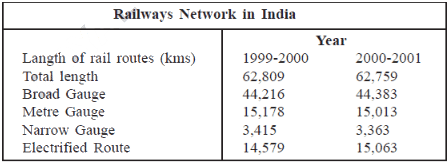
(i) What was the total length of railways route in 2000-2001?
(ii) How much increase occurred in the length of electrified routes between 1999-2000 and 2000-2001?
(iii) How is narrow gauge different from broad gauge?
Ans.
(i) 1,40,581 kms
(ii) 484 kms
(iii) Narrow Gauge (0.762 and 0.610 meters). Broad Gauge (1.676 meters) difference = 0.914 meters between Broad Gauge and Narrow Gauge.
Q.24. Describe the changing nature of international trade in the last fifteen years. [2011 (T-2)]

Ans. International trade has undergone a sea change in the last fifteen years. Exchange of commodities and goods have been superseded by the exchange of information and knowledge. India has emerged as a software giant at the international level and is earning large foreign exchange through the export of information technology.
Q.25. Name the longest National Waterway of India. Write any three points of importance of waterways? [2011 (T-2)]
Ans. The Ganga river waterways between Allahabad and Haldia (1620 km) N.W. No. 1 is the longest waterways of India.
The three points of importance of waterways are
(i) cheapest means of transport
(ii) suitable for carrying heavy and bulky goods.
(iii) It is a fuel efficient and environmentally friendly mode of transport.
Q.26. “Modern means of transport and communication serve as lifelines of our nation.” Explain.
Ans. Modern means of transport and communication serve as lifelines of our nation. It integrates local, national and global trade by boosting the economy and providing the comforts of life.
Q.27. How do physical and economic factors influence the distribution pattern of the Indian railway network? Explain with suitable examples. [2004 & 2009]

Ans. The distribution pattern of the railway network in India has been greatly influenced by physical and economic factors.
Level lands of the Northern Plains of India with high density of population, rich agricultural resources and greater industrial activity have favored the development of railways in this region. The region, therefore, has the densest network of railways in India. The rugged terrain of the Himalayan mountain region in the north and the north-eastern states with sparse population and lack of economic opportunities are unfavorable for construction of railway lines and railway network is lacking in these regions.
Sparsely populated sandy deserts of Rajasthan, hilly contiguous tracts of the Sahyadri swamps of Gujarat, forested tracks of Madhya Pradesh, Chhattisgarh, Orissa and Jharkhand, frequently flooded floodplains of Bihar and Assam have posed great difficulty in laying of railway lines. On account of the economic importance of the region, the Konkan Railways were developed in recent times along the west coast in spite of problems of sinking of tracks, landslides and need for construction of tunnels.
Q.1. Write a short note on the Golden Quadrilateral and the North-South and East-West Corridors.
Ans. The government has launched a major road development project linking Delhi – Kolkata – Chennai – Mumbai – Delhi by six-lane Super Highways. This is known as Golden Quadrilateral Super Highways as it links the four major metro cities. The general road network formed as a result is more or less quadrilateral in shape. It aims to improve linkage between the mega cities. It has a total length of 5846 km.

The North-South Corridor and the East-West Corridor, linking the terminal stations of Srinagar in Jammu and Kashmir in the north, Kanyakumari in Tamil Nadu in the south, Silchar in Assam in the east and Porbandar in Gujarat in the west, are part of the Golden Quadrilateral Super Highway Project. The North-South and East-West Corridors have a length of 7142 km. These highway projects are being implemented by the National Highway Authority of India (NHAI).

The major objective of these Super Highways is to reduce the time and distance between the big cities of India by providing opportunity for free movement of traffic, thus increasing connectivity between them.
Q.2. Which are the three important networks of pipeline transportation in the country? What is the significance of developing pipeline transportation in India?
Ans. The three important networks of pipeline transportation in the country are :
(a) From oil fields in upper Assam to Kanpur in Uttar Pradesh, via Guwahati, Barauni and Allahabad. It has branches from Barauni to Haldia, via Rajbandh, Rajbandh to Maurigram and Guwahati to Siliguri.
(b) From Salaya in Gujarat to Jalandhar in Punjab via Viramgam, Mathura, Delhi and Sonipat. It has branches to connect Koyali in Gujarat, Chakshu and other places.
(c) Gas pipeline from Hazira in Gujarat to Jagdishpur in Uttar Pradesh. via Bijapur in Madhya Pradesh. It has branches in Kota in Rajasthan, Shahjahanpur, Babrala and other places in Uttar Pradesh.
The pipelines have played a significant role in the development of refineries like Barauni, Mathura, Panipat at far inland locations, away from producing areas to cater to the demand of the inland markets. The development of gas-based fertilizer plants in agricultural regions away from petroleum-producing areas have also been possible due to pipeline transport.
Q.3. What are the advantages of waterways as a means of transport? Mention the names of three National Waterways in India.
Ans. Waterways are the cheapest mode of transport. Neither construction cost, nor maintenance cost is required for the waterways as they use the rivers, lakes, seas and oceans as highways. They are suited for the transport of bulky and heavy raw materials. Waterways is a fuel efficient and environment friendly mode of transportation. The boats and steamers, even if mechanized, consume much less fuel and do not pollute the surrounding.
Indian National Waterways

The following waterways have been declared as the National Waterways by the Government :
(a) The Ganga river between Allahabad and Haldia (1620 km) – National Waterway No. 1.
(b) The Brahmaputra river between Sadiya and Dhubri (891 km) – National Waterway No. 2.
(c) The West-Coast Canal in Kerala (Kottapuram – Komman, Udyogamandal and Champakkara canals - 205 km) – National Waterway No. 3.
Q.4. Which two modes of transport are widely used within the north-eastern states of India? Why?
Ans. Inland Waterway and Airways are the two modes of transport which are widely used in the northeastern states of India. The northeastern part of the country is marked with the presence of hilly terrain, dissected relief, dense forests, large number of rivers, heavy rainfall as well as international frontiers. As a result, roadways and railways cannot develop properly and are lacking in this region.
The Brahmaputra and its tributaries are therefore used by the local people for inland navigation as it is cheap and convenient to use. The Brahmaputra river between Sadiya and Dhubri in Assam has been declared as National Waterways No. 2 by the Government, on account of its importance.
Air travel is another preferred mode of travel in these areas as airways can cross over geographical obstacles of the region with great ease. During heavy rainfall and frequent floods, airways become the only mode of transport. Air transport is also subsidized in these northeastern states and special provisions are made to extend the services to the common people.
Q.5. Which port serves the rich hinterland of Ganga-Brahmaputra basin? Write a short note on this port. What is the significance of the ports in India’s economy?
Ans. The Kolkata port serves the large and rich hinterland of the Ganga-Brahmaputra basin covering the states of West Bengal, Assam, Bihar and eastern Uttar Pradesh. Tea, jute and cotton textiles, coal, lac, hides, engineering goods are some items of export from this region via Kolkata port.
The Kolkata port is an inland riverine port situated on the left bank of the River Hooghly in West Bengal. It is located inland at a distance of 128 km from the Bay of Bengal. It is a tidal port. As a result, the port faces the problem of siltation and requires constant dredging. It is the most important port in the eastern region. Ports hold a special position in India’s international trade. India’s trade with foreign countries is carried on mainly through the ocean routes from the ports located along the coast. 95 percent of the country’s trade volume (68 percent in terms of value) is moved by the sea via the ports. Hence, ports have great significance in the economy of India.
Q.6. What is the significance of airways as a mode of transport? Mention two merits and one demerit of airways.
Ans. Airways are the fastest, most comfortable and prestigious mode of transport in recent times. They can easily cross over geographical boundaries and vast stretches of seas and oceans. They can negotiate over difficult terrain like high mountains, dissected terrain, dreary desert, dense forests with great ease, within a short period of time. Fast international travel between different countries of the world has been possible because of the development of airways. Airways play a vital role during natural and man-made calamities like floods, famines, earthquakes, epidemics and war. They help in rescue operations and provide relief to the people in affected areas within a short time.
Two merits of airways are:
(a) It is the fastest mode of transportation. Thousands of kilometers are covered within a few hours.
(b) It is the most comfortable mode of transportation.
A demerit of airways is: It is the costliest mode of transportation and is out of the reach of common people.
Lifelines of National Economy class 10 ncert geography long question
Q.1. Write a short note on the Golden Quadrilateral and the North-South and East-West Corridors.
Ans. The government has launched a major road development project linking Delhi – Kolkata – Chennai – Mumbai – Delhi by six-lane Super Highways. This is known as Golden Quadrilateral Super Highways as it links the four major metro cities. The general road network formed as a result is more or less quadrilateral in shape. It aims to improve linkage between the mega cities. It has a total length of 5846 km.

The North-South Corridor and the East-West Corridor, linking the terminal stations of Srinagar in Jammu and Kashmir in the north, Kanyakumari in Tamil Nadu in the south, Silchar in Assam in the east and Porbandar in Gujarat in the west, are part of the Golden Quadrilateral Super Highway Project. The North-South and East-West Corridors have a length of 7142 km. These highway projects are being implemented by the National Highway Authority of India (NHAI).
The major objective of these Super Highways is to reduce the time and distance between the big cities of India by providing opportunity for free movement of traffic, thus increasing connectivity between them.

Q.2. Which are the three important networks of pipeline transportation in the country? What is the significance of developing pipeline transportation in India?
Ans. The three important networks of pipeline transportation in the country are :
(a) From oil fields in upper Assam to Kanpur in Uttar Pradesh, via Guwahati, Barauni and Allahabad. It has branches from Barauni to Haldia, via Rajbandh, Rajbandh to Maurigram and Guwahati to Siliguri.
(b) From Salaya in Gujarat to Jalandhar in Punjab via Viramgam, Mathura, Delhi and Sonipat. It has branches to connect Koyali in Gujarat, Chakshu and other places.
(c) Gas pipeline from Hazira in Gujarat to Jagdishpur in Uttar Pradesh. via Bijapur in Madhya Pradesh. It has branches in Kota in Rajasthan, Shahjahanpur, Babrala and other places in Uttar Pradesh.
The pipelines have played a significant role in the development of refineries like Barauni, Mathura, Panipat at far inland locations, away from producing areas to cater to the demand of the inland markets. The development of gas-based fertilizer plants in agricultural regions away from petroleum-producing areas have also been possible due to pipeline transport.
Q.3. What are the advantages of waterways as a means of transport? Mention the names of three National Waterways in India.
Ans. Waterways are the cheapest mode of transport. Neither construction cost, nor maintenance cost is required for the waterways as they use the rivers, lakes, seas and oceans as highways. They are suited for the transport of bulky and heavy raw materials. Waterways is a fuel efficient and environment friendly mode of transportation. The boats and steamers, even if mechanized, consume much less fuel and do not pollute the surrounding.
Indian National Waterways

The following waterways have been declared as the National Waterways by the Government :
(a) The Ganga river between Allahabad and Haldia (1620 km) – National Waterway No. 1.
(b) The Brahmaputra river between Sadiya and Dhubri (891 km) – National Waterway No. 2.
(c) The West-Coast Canal in Kerala (Kottapuram – Komman, Udyogamandal and Champakkara canals - 205 km) – National Waterway No. 3.
Q.4. Which two modes of transport are widely used within the north-eastern states of India? Why?
Ans. Inland Waterway and Airways are the two modes of transport which are widely used in the northeastern states of India. The northeastern part of the country is marked with the presence of hilly terrain, dissected relief, dense forests, large number of rivers, heavy rainfall as well as international frontiers. As a result, roadways and railways cannot develop properly and are lacking in this region.
The Brahmaputra and its tributaries are therefore used by the local people for inland navigation as it is cheap and convenient to use. The Brahmaputra river between Sadiya and Dhubri in Assam has been declared as National Waterways No. 2 by the Government, on account of its importance.
Air travel is another preferred mode of travel in these areas as airways can cross over geographical obstacles of the region with great ease. During heavy rainfall and frequent floods, airways become the only mode of transport. Air transport is also subsidized in these northeastern states and special provisions are made to extend the services to the common people.
Q.5. Which port serves the rich hinterland of Ganga-Brahmaputra basin? Write a short note on this port. What is the significance of the ports in India’s economy?
Ans. The Kolkata port serves the large and rich hinterland of the Ganga-Brahmaputra basin covering the states of West Bengal, Assam, Bihar and eastern Uttar Pradesh. Tea, jute and cotton textiles, coal, lac, hides, engineering goods are some items of export from this region via Kolkata port.
The Kolkata port is an inland riverine port situated on the left bank of the River Hooghly in West Bengal. It is located inland at a distance of 128 km from the Bay of Bengal. It is a tidal port. As a result, the port faces the problem of siltation and requires constant dredging. It is the most important port in the eastern region. Ports hold a special position in India’s international trade. India’s trade with foreign countries is carried on mainly through the ocean routes from the ports located along the coast. 95 percent of the country’s trade volume (68 percent in terms of value) is moved by the sea via the ports. Hence, ports have great significance in the economy of India.
Q.6. What is the significance of airways as a mode of transport? Mention two merits and one demerit of airways.
Ans. Airways are the fastest, most comfortable and prestigious mode of transport in recent times. They can easily cross over geographical boundaries and vast stretches of seas and oceans. They can negotiate over difficult terrain like high mountains, dissected terrain, dreary desert, dense forests with great ease, within a short period of time. Fast international travel between different countries of the world has been possible because of the development of airways. Airways play a vital role during natural and man-made calamities like floods, famines, earthquakes, epidemics and war. They help in rescue operations and provide relief to the people in affected areas within a short time.

Two merits of airways are:
(a) It is the fastest mode of transportation. Thousands of kilometers are covered within a few hours.
(b) It is the most comfortable mode of transportation.
A demerit of airways is: It is the costliest mode of transportation and is out of the reach of common people.
Comments
Post a Comment