A abampere (aA) The unit of electric current in the CGSeniu system, defined as that current that, if flowing through two parallel conductors of negligible cross section and infinite length, placed 1 cm apart in vacuo, would produce on each conductor a force of 1 dyne per centimeter of length. 1 abampere = 1 abcoulomb/s = r statampere (where c = speed of light in cm/s) = 10 ampere. aberration Imperfect image formation due to geometric imperfections in the optical elements of a system ablation 1 . The wasting of glacier ice by any process (calving, melting, evaporation, etc.). 2. The shedding of molten material from the outer sur- face of a meteorite or tektite during its flight through the atmosphere. absolute age The age of a natural substance, of a fossil or living organism, or of an artifact, obtained by means of an absolute dating method. See absolute dating method. absolute density Density in kg/m' or, more commonly, in g/cm\ both at STP. Cf. density, relative density abso
Physical Features of India class 9 geography MCQ & SAQ
Physical Features of India class 9 geography NCERT SOLUTION
1. The names of the glaciers and passes that lie in Great Himalayas
Answer
Glaciers in the Great Himalayas — Gangotri, Chaturangi, Bhagirathi, Kharak, Satopanth, Kamet, Milam and Pindari.
Passes in the Great Himalayas — Karakoram pass, Shipkila pass, Nathula, Bomdila pass.

2. The names of the states where the highest peaks are located.
Answer
Mountain peaks - States
Kanchenjunga - Sikkim
Nanga Parbat - Jammu and Kashmir
Nanda Devi - Uttarakhand
Kamet - Uttarakhand
Namcha Barwa - Assam
Page No: 15
Exercise
1. Choose the right answer from the four alternatives given below :
(i) A landmass bounded by sea on three sides is referred to as
(a) Coast
(b) Island
(c) Peninsula
(d) None of the above.
► (c) Peninsula
(ii) Mountain ranges in the eastern part of India forming its boundaries with Myanmar
are collectively called :
(a) Himachal
(b) Uttaranchal
(c) Purvanchal
(d) None of the above
► (c) Purvanchal
(iii) The western coastal strip south of Goa is referred to as

(a) Coromandel
(b) Konkan
(c) Kannad
(d) Northern Circar
► (c) Kannad
(iv) The highest peak in the Eastern Ghats is
(a) Anai Mudi
(b) Kanchenjunga
(c) Mahendragiri
(d) Khasi
► (c) Mahendragiri
2. Answer the following questions briefly:
(i) What are tectonic plates?
(ii) Which continents of today were parts of the Gondwana land?
(iii) What is bhabar?
(iv) Name the three major divisions of the Himalayas from north to south.
(v) Which plateau lies between the Aravali and the Vindhya ranges?
(vi) Name the island group of India having coral origin.
Answer
(i) Large fragments of the Earth’s crust and upper mantle separated due to the convection currents are called tectonic plates.
(ii) South America, South Africa, part of Asia (India, Arabia, Malaya), Australia and Antarctica continents were parts of the Gondwana land.
(iii) The Bhabar is that narrow belt of the plain which is covered with pebbles and lies along the foothills of the Shiwaliks from the Indus to the Tista.
(iv) The Great or the Inner Himalayas or the Himadri, the Middle Himalayas or the Himachal, and the Outer Himalayas or the Shivaliks.
(v) The Malwa plateau lies between the Aravali and the Vindhya Ranges.
(vi) Lakshadweep Islands is an island group of India having coral origin.
Page No: 16
3. Distinguish between
(i) Converging and Diverging Tectonic Plates.
(ii) Bhangar and Khadar
(iii) Western Ghats and Eastern Ghats
Answer
(i)
(ii)
(iii)
4. Describe how the Himalayas were formed.
Answer
According to the Theory of Plate Tectonics, the Earth's crust was initially a single, giant supercontinent called Pangea. Gradually, Pangea began to split into a number of pieces due to convection currents and formed Angaraland and Gondwanaland. Angaraland is the Eurasian landmass and Gondwanaland includes India, Australia, S. Africa and S. America as one single land mass. The Indo-Australian plate separated from Gondwanaland due to convection currents and drifted towards the north. Due to this collision, the sedimentary rocks which were accumulated in the geosyncline known as the Tethys were folded to form the mountain system of western Asia and the Himalaya.
5. Which are the major physiographic divisions of India? Contrast the relief of the Himalayan region with that of the Peninsular Plateau.
Answer

The major physiographic divisions of India are :
(i) The Himalayan Mountains
(ii) The Northern Plains
(iii) The Peninsular Plateau
(iv) The Indian Desert
(v) The Coastal Plains
(vi) The Islands
6. Give an account of the Northern Plains of India.
Answer
The northern plain has been formed by the interplay of the three major river systems, namely the Indus, the Ganga and the Brahmaputra along with their tributaries. This plain is formed of alluvial soil which is suitable for agriculture. It spreads over an area of 7 lakh sq. km. The plain is a densely populated physiographic division. The Northern Plain is broadly divided into three sections, Punjab Plains, Ganga Plains and Brahmaputra plains. According to the variations in relief features, the Northern plains can be divided into four regions. Bhabar, a narrow belt of pebbles which lie at the foot of Shivaliks. Terai lies next to Bhabar which is a wet and marshy area with wildlife and forests. Bhangar is made up of older alluvium plains which rise above the level of the flood plains. Khadar is a younger alluvium of the flood plains.
7. Write short notes on the following.
(i) The Indian Desert
(ii) The Central Highlands
(iii) The Island groups of India
Answer
(i) The Indian desert lies towards the western margins of the Aravali Hills. It is an undulating sandy plain covered with sand dunes called barchans. This region receives very low rainfall below 150 mm per year. It has an arid climate with low vegetation cover. Streams appear during the rainy season. Soon after they disappear into the sand as they do not have enough water to reach the sea. Luni is the only large river in this region.
(ii) The part of the peninsular plateau lying to the north of the Narmada River covering a major area of the Malwa plateau is known as the Central Highlands. The Vindhya range is bounded by the Central Highlands on the south and the Aravalli range on the northwest. The flow of the rivers draining this region, namely the Chambal, the Sind, the Betwa and Ken is from southwest to northeast, thus indicating the slope. The Central Highlands are wider in the west but narrower in the east. The eastward extensions of this plateau are locally known as the Bundelkhand and Baghelkhand. The Chotanagpur plateau marks the further eastward extension, drained by the Damodar River.
(iii) India has two main island groups, namely Lakshadweep and Andaman and Nicobar island. The Lakshadweep consists of many small islands located opposite the Kerala coast in the Arabian Sea. The islands of this group are formed of coral deposits. It covers a small area of 32 sq km. Kavaratti island is the administrative headquarters of Lakshadweep. The Andaman and Nicobar Islands, on the other hand, are larger in size. They are more in number and more widely scattered. These islands are an elevated portion of submarine mountains.

Map Skills
On an outline map of India show the following.
(i)Mountain and hill ranges – the Karakoram, the Zaskar, the Patkai Bum, the Jaintia, the Vindhya range, the Aravali, and the Cardamom hills.
(ii) Peaks – K2, Kanchenjunga, Nanga Parbat and the Anai Mudi.
(iii) Plateaus, Chotanagpur and Malwa
(iv) The Indian Desert, Western Ghats, Lakshadweep Islands
Answer

Project/Activity
Locate the peaks, passes, ranges, plateaus, hills, and duns hidden in the puzzle.Try to find where these features are located. You may start your search horizontally, vertically or diagonally.

Answer

Vertical
CHOTANAGPUR
ARAVALI
KONKAN
JAINTIA
MALWA
NILGIRI
SHIPKILA
VINDHYA
BOMDILA
SAHYADRI
SATPURA
Horizontal
NATHULA
CARDAMOM
GARO
KANCHENJUNGA
ANAMUDI
EVEREST
PATLI
Physical Features of India class 9 geography MCQ
Question.The northern most range of the Himalayas is known as
(a) Himadri
(b) lesser Himalaya
(c) Shivalik
(d) none of the above.
Answer : A

Question. Dudhwa National Park is located in the state of
(a) Assam
(b) Uttar Pradesh
(c) Madhya Pradesh
(d) Rajasthan
Answer : B
Question. The soil containing calcareous deposits is locally known as
(a) Bhangar
(b) Khadar
(c) Bhabar
(d) Kankar
Answer : D
Question.The soil containing calcareous deposits is locally known as
(a) Bhangar
(b) Khadar
(c) Bhabar
(d) Kankar
Answer : D
Question. Which of the following divisions of India has the oldest landmass?
(a) The Himalayas
(b) The Northern Plains
(c) The Peninsular Plateau
(d) The Indian Desert
Answer : C

Question. The northernmost range of the Himalayas is known as
(a) Himadri
(b) Lesser Himalaya
(c) Shivalik
(d) Himachal.
Answer : A
Question. The Kangra and Kullu valley are located in
(a) Uttarakhand
(b) Jammu and Kashmir
(c) Himachal Pradesh
(d) Uttar Pradesh
Answer : C
Question. Majuli is a riverine island located in the river
(a) Ganga
(b) Brahmaputra
(c) Yamuna
(d) Kaveri
Answer : B
Question. The highest peak in the Eastern Ghats is
(a) Anai Mudi
(b) Doda Betta
(c) Ooty
(d) Mahendragiri
Answer : D
Question. Jaisalmer is in
(a) Himachal Pradesh
(b) Rajasthan
(c) Gujarat
(d) Uttar Pradesh
Answer : B

Question. Barchans are found in
(a) desert regions
(b) plains
(c) plateaus
(d) hilly regions
Answer : A
Question. Which of the following has not been a factor in the creation and modification
of India’s relief features?
(a) Geological formations
(b) Population density
(c) Weathering
(d) Erosion and deposition
Answer : B
Question. A landmass bounded by sea on three sides is referred to as
(a) Coast
(b) Island
(c) Peninsula
(d) None of the above
Answer : C
Question. The northern part of the western coast is called the
(a) Konkan
(b) Kannad plain
(c) Malabar coast
(d) Coromandel coast
Answer : A
Question. Lake Chilika lies in the state of
(a) Jharkhand
(b) Telangana
(c) Odisha
(d) Tamil Nadu
Answer : C
Question. A landmass bounded by sea on three sides is referred to as
(a) Coast
(b) Island
(c) Peninsula
(d) None of the above
Answer : C
Question. Which islands of India are called Coral Islands?
(a) Lakshadweep
(b) Andaman and Nicobar
(c) Yanam
(d) Daman and Diu
Answer : A
Question. In which division of the Himalayas are the famous valleys of Kashmir, Kangra and Kullu located?
(a) The Himadri
(b) The Himachal
(c) The Shivaliks
(d) The Duns
Answer : B
Question. Which of the following is the highest peak of the Himalaya in India?
(a) Mt. Everest
(b) Kanchenjunga
(c) Nanga Parbat
(d) Nandadevi
Answer : B
Question. The Himalayan uplift out of the Tethys Sea and subsidence of the northern flank of the peninsular plateau resulted in the formation of a large basin. Which of the following physical divisions of India was formed due to the filling up of this depression?
(a) The Himalayas
(b) The Northern Plains
(c) The Peninsular Plateau
(d) The Coastal Plains
Answer : B
Question. Which of the following physical divisions of India has the oldest landmass?
(a) The Himalayas
(b) The Northern Plains
(c) The Peninsular Plateau
(d) The Indian Desert
Answer : C
Question. The longitudinal valleys lying between lesser Himalayas and Shivaliks are known as _______.
(a) Kangra Valley
(b) Patkai Bum
(c) Passes
(d) Duns
Answer : D
Question. Which two hills are located in the south-east of Eastern Ghats?
(a) Mizo Hills and Naga Hills
(b) Javadi Hills and Shevaroy Hills
(c) Patkoi Hills and Manipuri Hills
(d) Mizo Hills and Patkoi Hills
Answer : B
Question. What are the Lesser Himalayas known as?
(a) Himadri
(b) Himachal
(c) Shivaliks
(d) Purvanchal
Answer : C
Question. Geologically, which of the following physiographic divisions of India is supposed to be one of the most stable land blocks?
(a) The Himalayas
(b) The Northern Plains
(c) The Peninsular Plateau
(d) The Indian Desert
Answer : C
Question. From the point of view of geology, which of the following physiographic divisions of India is considered to be the most unstable zone?
(a) The Himalayan Mountains
(b) The Peninsular Plateau
(c) The Indian Desert
(d) The Islands
Answer : A
Question. A narrow gap in a mountain range providing access to the other side is :
(a) Mound
(b) Pass
(c) Strait
(d) Valley
Answer : B
Question. The Himalayas consist of three parallel ranges in its longitudinal extent. Which of the following is the name of the northern-most range?
(a) The Himadri
(b) The Himachal
(c) The Shivaliks
(d) The Purvanchal
Answer : A
Physical Features of India class 9 geography SAQ
.1. Describe the Theory of Plate Tectonics.
Ans. A plausible theory presented by earth scientists to explain the formation of continents and ocean basins and the various landforms is the ‘Theory of Plate Tectonics’. According to the theory, the crust of the earth has been formed out of seven major and some minor tectonic plates.

According to the earth scientists, millions of years ago, the world consisted of a supercontinent ‘Pangaea’ surrounded by the primeval ocean ‘Panthalasa’. The present continents and intervening oceans were formed due to splitting of the crust into plates due to convection currents and drifting of these plates.
Q.2. Name the different major physiographic divisions of India. Write a note on any one of the physiographic divisions of India. (Important)
Ans. The major physiographic divisions of India are as follows:
The Coastal Plains : The Peninsular Plateau of India is flanked by a stretch of narrow coastal plains to its west and east. The Western Coastal Plain is a narrow strip of plain stretching along the Arabian Sea lying to its west and flanked by the Western Ghats to its east. The northern part of the West Coast is called the Konkan (Mumbai to Goa), the central stretch is called the Kannad while the southern part is called the Malabar Coast.
The Eastern Coastal Plain is a comparatively wide and level stretch running along the Bay of Bengal lying to its east with the Eastern Ghats rising to its west. It is known as Northern Circar in the north, while its southern part is referred to as the Coromandel Coast.
Q.3. How was the Great Northern Plains of India formed? Give a brief description.
Ans. The formation of the Himalayas due to upliftment of sediments out of the Tethys Sea and subsidence of the northern flank of the Peninsular Plateau resulted in the formation of a large basin.
Over millions of years this depression gradually got filled up with alluvium deposited by the three major river systems – the Indus, the Ganga and the Brahmaputra flowing from the Himalayas in the north. Sediments were also deposited by the tributaries of these rivers rising from the mountains in the north as well as the Peninsular Plateau to its south. As a result, the fertile Indo-Gangetic or Northern Plains, and the Brahmaputra Plain in the northeast, were formed.
As the Himalayas gained in height, the rivers, glaciers and other agents of denudation became increasingly active in erosion. As a result, large amounts of silt got deposited in the shrinking Tethys.
Q.4. Where are the Western and the Eastern Ghats situated? Write a small note on each.
Ans. The Western and the Eastern Ghats are situated in the Peninsular Plateau region. The Western Ghats mark the western edge of the Deccan Plateau and lie parallel to the Western Coast.
The Eastern Ghats mark the eastern edge of the Deccan Plateau. They stretch from the Mahanadi Valley to the Nilgiri Hills in the south. The eastern coastal plain runs to its east.
The Western Ghats are continuous and regular and can be crossed only through passes like the Thal, Bhor and the Pal Ghats. They are comparatively high in elevation (average 900 to 1600 meters). No major river cuts across the Western Ghats.
The Eastern Ghats are discontinuous and irregular. They are of relatively lower elevation (average 600 m). They are dissected by rivers draining into the Bay of Bengal.

Q.5. Define tectonic or lithospheric plates.
Ans. Earth scientists have put forward the view that the Earth’s crust or the lithosphere is not a continuous block. It consists of several large and small, rigid, irregularly shaped plates (slabs) which include continents and the ocean floor. These slabs are moving or drifting in relation to each other by about 2.5 cm to 5 cm each year. These crustal slabs are called tectonic or lithospheric plates. According to the ‘Theory of Plate Tectonics’ put forward by the Earth scientists, the earth’s crust has been formed out of seven major and some minor tectonic plates or lithospheric plates.
Q.6. Which plateau lies between the Aravali and the Vindhya range? Write a brief note on this plateau.
Ans. The Malwa Plateau lies between the Aravali hills and the Vindhya range. The Aravali hills lie to the west of the plateau and the Vindhya range lies to its south.
The part of the peninsular plateau lying to the north of the Narmada river, covering a major area of the Malwa plateau, is known as the Central Highlands.The Malwa plateau lies in Madhya Pradesh. It is composed of extensive lava flows. There are rolling plains separated by flat-topped hills. The plateau is largely broken in the form of ravines near the Chambal Valley in its east.
Q.7. What do you understand by 'duns'? Where are they situated in our country? Give any two examples of duns.
Ans. The longitudinal valleys lying between Lesser Himalaya and the Shivaliks are known as duns. Dehradun and Kotli Dun are two examples of duns.
Q.8. What are corals? Name and describe the island group which is of coral origin.
Ans. Corals are short-lived microscopic organisms, which live in colonies. They flourish in shallow, mud-free and warm waters. They secrete calcium carbonate. The coral secretion and their skeletons form coral deposits.
The Lakshadweep islands group, lying close to the Malabar Coast of Kerala, is composed of small coral islands.
Q.9. Describe 'Bhabar' and 'Terai'.
Ans. Bhabar is a pebble-studded formation situated at the base of mountains and plains in the Himalayan region. Terai is a sloping land at the foothills of the Nepal Himalayas. The Terai receives heavy rainfall and is densely forested.
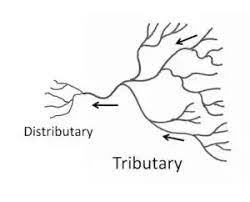
What is the difference between a tributary and a distributary?
Answer:
A Tributary: A tributary is that river which joins the main river, and increases the volume of water. It is generally found in the upper or the middle course of a river. For example, the Yamuna is the main tributary of the river Ganga.
A Distributary: It is that river which originates from a main river. It is formed near the river’s mouth before it falls into the sea. It is found in the lower course of the river. For example, Hooghly is the main distributor of Ganga.
Name the three major divisions of Himalayas from the north to the south.
Answer:
The three major divisions of Himalayas from north to south are:
The northernmost range is known as the Great Himalayas or Inner Himalayas or Himadri. It is the most continuous range consisting of the loftiest peaks. It has an average height of 6000 meters. It consists of all the prominent Himalayan peaks.
The southern range of Himadri which is known as the Himachal or the lesser Himalayas lies to the South of Himadri. It forms the most rugged mountain system. The ranges are mainly composed of highly compressed and altered rocks. The altitude varies between 3700 and 4500 meters and its average width is 50 kms.
The outermost range of the Himalayas is known as Shiwaliks. Its height varies between 900 meters and 1100 meters. This range is composed of unconsolidated sediments brought down by rivers from the main Himalayan ranges. These are also called foothill ranges. They represent the southernmost division of the Himalaya.
Name the southernmost range of Himalaya. Mention any four features of this range.
Answer:
The southernmost range of the Himalayas is called Shiwaliks.
Features:
The outermost range of the Himalayas is called the Outer Himalayas or Shiwaliks.
They extend over a width of 10-15 km.
Their altitude varies between 900-1100 meters.
They are discontinuous ranges and are composed of unconsolidated sediments, gravel and alluvium brought down by the rivers from main Himalayan ranges located farther north.
Longitudinal valleys known as Duns lie between the lesser Himalayas and Shiwaliks. e.g., Dehradun, Kote Dun, Path Dun. (any four)
How is the Himadri range different from the Himachal range? Mention any three differences.
Answer:
Differentiate between Western Himalayas and Eastern Himalayas.
Answer:
Write about the main features of the Shiwaliks.
Answer:
It is the outermost range of the Himalayas.
The average altitude of the Shiwalik range varies between 900 m and 1,100 m above the sea level, and extends over a width of about 10-50 km.
This range is made of unconsolidated material such as mud, silt and soft rocks and is prone to earthquakes and landslides.
Some narrow valleys are found between the Shiwaliks and the Himachal. They are called ‘duns’. For example, Dehradun is situated in one such valley.
How did the northern plains come to existence? Write two points briefly. Also mention two features of these plains.
Answer:
(i) The northern plains have been formed by the interplay of the three major river systems, i.e., the Indus, the Ganga and the Brahmaputra.
(ii) The northern plain is formed of the alluvial soil brought by these rivers.
Features:
These plains are very fertile.
These are densely populated.
Why are Northern Plains agriculturally productive parts of India? Explain.
Answer:
The deposition of alluvium in a vast basin lying at the foothills of the Himalaya over millions of years, formed this fertile plain. It spreads over an area of 7 lakh sQuestion km.
The plain is about 2400 km. and 240 to 320 km. broad, is a densely populated physiographic division.
With a rich soil cover combined with adequate water supply and favorable climate, it is a very productive part of India.
Which three river systems form the northern plains of India? Mention main features.
Answer:
The northern plain has been formed by the interplay of the three major river systems—the Indus, the Ganga and the Brahmaputra.
Features:
The river Indus and its tributaries form the western part of the northern plain which is referred to as the Punjab plains. The larger part of this plain lies in Pakistan.
The Ganga plain extends between the Ghaggar and Teesta rivers. It spreads over the states of North India; Haryana, Delhi, U.P., Bihar, partly Jharkhand and West Bengal.
The Brahmaputra plain particularly lies mainly in Assam. It forms the largest riverine islands in the world.
state any three differences between the Himadri range and the Shiwalik range.
Answer:
What is a delta? Name some deltas of the Indian sub-continent.
Answer:
The triangular deposition of sediments at the mouth of a river is known as a delta.
The Ganga-Brahmaputra Delta.
The Mahanadi Delta.
The Godavari Delta.
The Krishna Delta.
The Kaveri Delta.
What are Purvanchal hills? Mention any two features of these hills.
Answer:
Mountains along the eastern boundary of India are called the Purvanchal. There are medium heights. Some of the important mountains of Purvanchal are:
The Patkai Bum and the Naga Hills in the North.
The Mizo Hills in the South.
The Jaintia, the Khasi and the Garo hills from east to west.
Features:
They are made up of sandstone and sediments.
They are covered with dense forests.
They comprise Patkai Hills, Manipur hills etc. (any two)
Distinguish between Central highlands and the Deccan Plateau on the basis of rivers that flow and hill ranges.
Answer:
Give an account of the Deccan Plateau.
Answer:
An account of Deccan Plateau of India:
It is a triangular landmass that lies to the south of the river Narmada. The Satpura range flanks its broad base in the north while the Mahadev forms its eastern extensions.
The Deccan Plateau is higher in the west and slopes gently eastwards.
An extension of the Plateau is also visible in the north-east. It is locally known as the Meghalaya, Karbi Anglong Plateau and North Cachar Hills.
It is separated by a fault from the Chota Nagpur Plateau. Three prominent hill ranges from the West to East are the Garo, the Khasi and the Jaintia Hills. The Western Ghats and the Eastern Ghats mark the Western and Eastern edges of the Deccan Plateau respectively. The Western Ghats lie parallel to the western coast and Eastern Ghats lie parallel to the eastern coast.
Compare the main features of the Western Coastal Plain and Eastern Coastal Plain.
Answer:
Name the four major states which are the parts of the eastern coastal plains. Mention the two divisions of these coastal plains.
Answer:
The plains extend from the state of Tamil Nadu in the southern part to the state of West Bengal in the northern region of India. Other states include Andhra Pradesh and Odisha. The three main divisions into which the eastern coastal plains can be divided are Utkal Plains, Tamil Nadu Plains and the Andhra Plains.
(i) Utkal Plains: This is the coastal stretch of the state of Odisha and consists of the Mahanadi delta. The famous feature of the region is the Chilka Lake lying on the south of the Mahanadi Delta.
(ii) Tamil Nadu Plains: The plains extend from the Pulicat Lake to Kanyakumari. The prominent feature of the region is the Kaveri delta, the fertile soil and irrigation facilities of which make it a granary in South India.
(iii) Andhra Plains: The plains extend from the Utkal Plains on the North to Pulicat Lake in the south. The delta formation by the rivers Kaveri and Godavari happens to be an important feature of the region.
Describe any three features of coastal plains of India.
Answer:
The Peninsular plateau is flanked by a strip of narrow coastal strips running along the Arabian Sea on the west and the Bay of Bengal on the east.
The western coast, sandwiched between the Western Ghats and the Arabian Sea, is a narrow plain. It consists of three sections. The northern part of the coast is called the Konkan (Mumbai-Goa), the central stretch is called the Kannad Plain while the southern stretch is referred to as the Malabar coast.
The plains along the Bay of Bengal are wide and level.
In the northern part, it is referred to as the Northern Gircar, while the southern part is known as the Coromandel Coast.
Large rivers such as the Mahanadi, the Godavari, the Krishna and the Kaveri have formed an extensive delta on this coast. Lake Chilka is an important feature along the eastern coast.
Physical Features of India class 9 geography MCQ & SAQ
Q.1-. Write a note on the different parts of the Great Himalayan range.
Ans. 1. The Himalayas are the one of the loftiest and most rugged mountain systems of the world. The mountain ranges of the Himalayas run in a west-east direction from the Indus to the Brahmaputra, stretching along the entire northern boundary of India. Geologically they are young and structurally folded in the mountain system.

2. The Himalayas consist of three sections comprising parallel ranges running from west to east. The northernmost section is known as the Greater or Inner Himalayas. On account of its permanent snow cover and glaciers, the section is also termed as Himadri. It is the most continuous section. The average height of these ranges is 6000 meters. All the prominent and loftiest peaks of the Himalayas are located here. Some of prominent peaks are the Everest (8848 m) in Nepal, Kanchenjunga (8598 m in Sikkim), Nanga Parbat (in Kashmir), Nanda Devi (Uttarakhand) and Namcha Barwa (in Tibet, near Arunachal Pradesh) and Dhaulagiri and Annapurna in Nepal.
3. To the south of Himadri lie the rugged ranges of the Lesser Himalayas or the Himachal. Their average width is 50 km. The average height ranges between 3700 and 4500 meters. The Pir Panjal range, the Dhaula Dhar and Mahabharat ranges are important ranges. The famous valleys of Kashmir, the Kangra and the Kullu Valleys in Himachal are located in this range.
4. The outermost range of the Himalayas is called the Outer Himalayas or the Shivaliks. They extend over a width of 10-50 km. They are discontinuous ranges. Their average height is between 900 and 1100 meters. They are composed of unconsolidated sediments, gravel and alluvium brought down by the rivers that rise in the northern ranges. Hence, they are the youngest section of the Himalayas.
5. Longitudinal valleys known as duns lie between the Lesser Himalayas and Shivaliks, e.g., DehraDun, Kotli Dun, Patli Dun.
Q.2. Describe the formation of India from Gondwanaland.
Ans. According to the ‘Theory of Plate Tectonics’ presented by earth scientists, the earth’s crust is composed of tectonic plates. The movement of these plates have influenced the evolution of present landforms of India.
The southern part of the ancient supercontinent Pangaea is known as Gondwanaland. It included India, Australia, South Africa and South America as one single landmass. Geologically, the Peninsular Plateau, which is one of the oldest landmasses of the earth’s surface, was part of Gondwanaland.
Tectonic forces split the crust into a number of plates. A part of Gondwanaland, the Indo- Australian plate, drifted northwards. This resulted in the collision of this plate with the much larger Eurasian plate. The intervening portion between Angaraland in the north and Gondwanaland in the south was occupied by the Tethys Sea. Due to this collision, the sediments that had accumulated in the Tethys geosyncline were uplifted and folded. This resulted in the formation of the lofty Himalayas.

The Himalayan upliftment out of the sediments of the Tethys Sea and subsidence of the northern flank of the Peninsular Plateau resulted in the formation of a large basin. Over millions of years the depression gradually got filled with deposition of sediments by the rivers flowing from the mountains in the north and the Peninsular Plateau in the south. The interplay of three major river systems – the Indus, the Ganga, the Brahmaputra and their tributaries formed a fertile, flat land of extensive alluvial deposits known as the Northern Plains.
Q.3. Distinguish between the Northern Plains and the Peninsular Plateau. Ans. The Northern Plains
1. Geologically, the Northern Plains were formed in the recent geological period.
2. Northern Plains are the most recent landform.
3. They are being formed and reshaped by the river systems.
4. It is a fertile, level land.
5. The Northern Plains are formed of alluvial deposits brought down by the rivers.

6. The Northern Plains are divided into three sections :
(i) The Punjab Plains formed by the Indus and its tributaries. (ii) The Ganga Plains in North India.
(iii) The Brahmaputra Plain in Assam.
7. The Northern Plains are covered with rich, fertile alluvial soil, ideal for high agricultural production.
The Peninsular Plateau
1. Geologically, the Peninsular Plateau is part of Gondwanaland, the southern part of ancient supercontinent Pangaea.
2. The Peninsular plateau is part of the oldest landmass.
3. It is one of the most stable land blocks.
4. It is a plateau or tableland with gently rising rounded hills and wide shallow valleys.
5. The Peninsular Plateau is composed of old crystalline igneous and metamorphic rocks.
6. The Peninsular Plateau is divided mainly into two broad divisions :
(i) The Central Highlands and (ii) The Deccan Plateau.
7. A distinct feature of the Peninsular Plateau is the black soil area known as Deccan Trap. This soil is ideal for the growth of cotton.
Q.4. Which part of the Himalayas is known as Purvanchal? Write a short note on the Purvanchal Himalayas. Ans. The eastern hills and mountains of the Himalayas running along the eastern boundary of India are known as Purvanchal. They are located in the northeastern states of India.
The river Brahmaputra marks the easternmost boundary of the Himalayas. Beyond the Dibang gorge, the Himalayas bend sharply to the south and spread along India’s eastern border. They are known as Purvanchal. They run mostly as parallel ranges with valleys in between. They are mostly composed of strong sandstone, a sedimentary rock.
The Purvanchal are less spectacular than the Himalayas and are of medium height. The hills and ranges are covered with dense forests.Some important hills of the Purvanchal are :

(i) The Patkai Bum and Naga hills (ii) The Mizo hills and Manipur hills
(iii) The Garo, Khasi and Jaintia hills along Meghalaya-Bangladesh border. (iv) The Dafla hills in the north.
Q-5. Describe the important features of the Peninsular Plateau.
Ans. The Peninsular Plateau of India lies to the south of the Northern Plains and extends up to the tip of the Indian peninsula. The Peninsular Plateau is a tableland with gently rising rounded hills and broad, shallow valleys. It is roughly triangular in shape.
It is the oldest and the most stable landmass of India. The plateau is formed of old crystalline igneous and metamorphic rocks.
The Peninsular Plateau consists of two broad divisions – the Central Highlands and the Deccan Plateau. The part of the Peninsular plateau lying to the north of the Narmada river is known as Central Highlands. It comprises Malwa Plateau, Bundelkhand and Baghelkhand plateaus, the Vindhya Range and extends as the Chhota Nagpur Plateau. The Aravallis are highly denuded old hills that lie on the western and northwestern margins of the Peninsular Plateau.
The part of the Peninsular Plateau lying to the south of river Narmada is known as the Deccan Plateau. It is a triangular landmass with a broad base in the north and tapers southward. It is formed due to lava flows, so a greater part of it is composed of basaltic rocks of volcanic origin. It is flanked by the Satpura range in the north. The Mahadev, the Kaimur hills and Maikal range from its eastern extensions.
The Deccan Plateau is flanked by the Western Ghats in the west and Eastern Ghats in the east. The Western Ghats have comparatively higher elevations of average 900 to 1600 meters. The Eastern Ghats have an average elevation of 600 meters. So the plateau is higher in the west and slopes gently eastwards. The black soil area of the Deccan Plateau is known as Deccan Trap.
“The land of India displays great physical variations”. Justify this statement with five examples. HOTS
Answer:
Physical variations of land of India are:
Geologically, the Peninsular Plateau constitutes one of the ancient land masses on the earth’s surface. It was supposed to be one of the most stable land blocks.
The Himalayas and the Northern Plains are the most recent landforms.
From the viewpoint of geology, Himalayan Mountains form an unstable zone.
The whole mountain system of Himalaya represents a very youthful topography with high peaks, deep valleys and fast flowing rivers.
The Northern Plains are formed of alluvial deposits.
The Peninsular Plateau is composed of igneous and metamorphic rocks with gently rising hills and wide valleys, (any five)
Each physiographic region of India complements the other and makes the country richer in its natural resources.” Justify this statement with five examples.
Or
‘The diverse physical features of India are of immense value’.
Justify the statement by giving suitable examples.
Answer:
Importance of diverse physical features of India is as follows:
The northern mountains are the major sources of water and forest wealth.
The northern plains are the granaries of the country. They provide the base for early civilisations.
The plateau is a storehouse of minerals which has played a crucial role in the industrialisation of the country.
The coastal region and island groups provide sites for fishing and port activities.
The deserts are the storehouse of solar energy.
Explain the three types of plates and write the effects of movements of plates.
Answer:
The plate movements are classified into three types:
Some plates come towards each other and form convergent boundaries.
Some plates move away from each other and form divergent boundaries.
At times, they may also move horizontally past each other and form a transform boundary.
When two plates come together, they are known as convergent plates. They are also known as constructive plates. When two plates move far away from each other, they are known as divergent plates. When two plates coming towards each other collide or burst, they are known as transform plates. The movement of plates causes volcanic eruptions, earthquakes, formation of mountains etc.
Distinguish between Bhabhar and Terai.
Answer:
Describe any five features of the northern plains of India.
Answer:
Features of northern plains of India are:
(i) The northern plains have been formed from the alluvium deposited by the mountain rivers.
(ii) They are located between the Himalayan rivers in the north and the Peninsular Plateau in the south.
(iii) They turned the soil on the surfaced land fertile for growing a rich harvest of a variety of crops. This led to the development of the Indus river valley civilization.
(iv) They are made up of deposits of alluvium and cover an area of 7 lakh sQuestion km.
(v) They are a densely populated physiographic division of India and are believed to be highly productive in terms of agriculture.
(vi) The North Indian plains have the Indus river system in the west and the Ganga, Brahmaputra river system in the East.
(vii) The first include Jhelum, Chenab, Rabi, Beas. The Indus flows into the Arabian Sea.
The second includes Ganga-Brahmaputra which combines with Meghna at the point when it drains into the Bay of Bengal. They form the world’s largest and fastest growing delta.
On the basis of the difference of relief, they are divided into four parts—Bhabhar, Terai, Bhangar and Khadar.
(viii) The northern plain is divided into three sections— Punjab plain, Ganga plain and Brahmaputra plain. The Ganga plain has diverse relief features. It has four belts:
Bhabhar is a belt of pebbles extending from 8-16 kms in width in which stream disappears.
Terai is a wet, swampy, marshy region with thick forests and wildlife.
Bhangar is a terrace-like feature made of old alluvium. It contains calcareous deposits called Kankar.
Khadar is the floodplain which is renewed everywhere and is very fertile.
Which is the oldest landmass of India? Name its two broad divisions and explain any three features of each.
Answer:
The Great Peninsular Plateau lies to the south of the great plains and is the oldest landmass of India. It is triangular in shape. The river
Narmada divides it into two parts:
The Central Highlands and
The Deccan Plateau.
The Central Highlands:
It is made up of hard igneous and metamorphic rocks.
It comprises the Malwa Plateau, the small plateau of Bundelkhand and the Chhota Nagpur Plateau while the Western Ghats extend to the west of the Deccan Plateau.
Chambal, Sind and Betwa are three important rivers which flow through the Central Highlands.
It has been drained by tributaries of Yamuna and Ganga.
Bundelkhand in southern UP and Baghelkhand in northern Madhya Pradesh.
The Deccan Plateau:
It is a triangular landmass that lies to the south of river Narmada.
It is higher in the west and slopes gendy eastwards.
It is the largest unit of the Peninsular Plateau of India.
Satpura range, Mahadev hills, Maikal range covers the northern edge.
It is the oldest block made up of igneous and metamorphic rocks.
Describe any five features of the Central highlands of India.
Answer:
Features of Central Highlands:
The part of the Peninsular Plateau lying to the north of the Narmada river covering a major area of the Malwa Plateau is known as the Central Highland.
The Vindhya range is bounded by the Central Highland in the south and the Aravallis in the northwest. The further westward extension gradually merges with the sandy and rocky desert of Rajasthan.
The flow of the rivers draining this region, namely Chambal, the Sind, the Betwa and Ken is from southwest to northeast, thus indicating the slope.
The Central Highlands are wider in the West but narrower in the East.
The eastward extensions of this plateau are locally known as the Bundelkhand and Baghelkhand.
Comments
Post a Comment